
Content Creation
Enabling Participatory Urban Design through Extended Reality
The design of cities has a huge impact on the lives of its residents. However, residents do not have much say in this design.
Urban design solutions are usually expensive and take time to implement. This makes it difficult to test them with users, or integrate user feedback in the design process.
How might we enable urban designers to integrate user perspective into their design process?
Designing a system for participatory urban design


The proposed system is contingent on the ability to prototype and occupy simulations in extended reality.
However, this is a relatively niche skillset.
My solution: UrbanSculpt VR

UrbanSculpt VR is a tool allowing urban designers to create and occupy XR simulations of cities with no prior 3d model or XR development knowledge. It allows users to:
-
Quickly and inexpensively prototype solutions.
-
Test these solutions with users.
-
Collect feedback from these users.
-
Showcase the value of this research to all relevant stakeholders.
Journey of UrbanSculpt VR


Using map data, the tool helps the user generate an accurate model of Newport.
The user can add in interventions (Such as a bike lane) by dragging and dropping elements from an asset library.


This includes responsive assets such as crowds and traffic that are important for a realistic city simulation.
Residents of Newport test these interventions and raise potential concerns.
Eg. The bike lanes might result in reduced parking.

As they navigate and test the simulation, they can leave feedback using a panel of options.
This can be interacted with using the VR controllers.
The user of UrbanSculpt VR can view a compilation of the feedback as a visualisation is VR.
Visualising the collected data
The Value of the Final Visualisation
Historically, new mediums of data visualisation have provided unique insights.
In 1854, John Snow created a visual representation of cholera related deaths in London on a map. This format had not been previously explored. It quickly revealed a pattern in the spread of the disease that led to the discovery that cholera is not air borne.
Being able to walk through data in virtual reality could provide previously unimaginable insight.

Entry Point to UrbanSculpt VR
The entry point is a web platform where the user can download a 'Unity' file.

The unity file is loaded with a city simulation, asset library and XR compatibility.
In case the required city simulation has not been previously generated, the user receives detailed instructions on how to generate one using open source data.
Process Documentation
Closer look at the components
Documentation on how to generate a city simulation.
This use Mapbox, an open source map making software, and Blender, a 3d modelling software.

A model of Newport with an XR rig and locomotion systems.
This acts as a template for setting up new scenes.

A virtual car that can be connected to a a physical driving simulator.

A library of assets that might be useful in urban simulations.
This includes AI driven people, traffic and 3d models of infrastructure such as trees, street lights, bus stops and parks.
Building the assets
The city

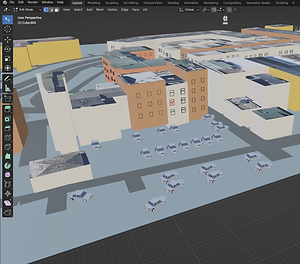

Mapbox:
I started with a satellite image of the city of Newport from Mapbox to generate the model.
Blender:
I used a plugin to generate buildings and roads, using the satellite image as reference. I then added trees, cars and certain landmarks, again using the image as a reference. It took some trial and error to find an aesthetic that was recognisable as a simulation, without being distracting to users.
Realistic Traffic Control:
I used the Unity Asset RTC to generate vehicle traffic in the scene. However, the traffic was not smart and could only follow a predetermined route and avoid collisions.Urban

Urban Traffic Control:
I used the Unity asset Urban Traffic Control to add pedestrians and responsive traffic to the scene.
Data visualisation

OpenBrush:
I created representations of how the visualisations of the navigation patterns and pose tracking would appear using OpenBrush.